Gaming
Days Gone Travel Guide: Know the locations across the vast world of Days Gone Map – Mod Breakdown
Apr
The Days Gone map is an open world of wilderness, survivor camps, and abandoned towns. We’ll tell you how to fast travel to quickly reach your locations. Here’s the Mod Breakdown of the full Days Gone map.
At first glance, you may think the Days Gone map is small, starting off in the Cascades region then progressing to the west near Hot Springs, there’s not much else to explore. when you progress further the Days Gone world begins to open up and you begin to explore the freaker apocalypse in an area twice the size.
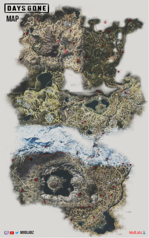
The cloudy white parts of the map indicate the unexplored area of the map, most of these areas are mountains that are inaccessible.
The top right corner of the map is Cascades, This is starting zone where Mark Copeland’s camp is in the south-west corner. Continuing to the top left corner of the map, this is the desert zone with the massive mountain in the middle is Hot Springs, which has Ada Tucker’s camp in the woodland area to the west.
Below Hot Springs zone is Iron Butte, This zone is largely populated by Rippers and for a large portion of the game is inaccessible. Heading to the east is Lost Lake, you’ll find Iron Mike’s camp in the middle surrounded by Lost Lake on both side.
In the lower right corner of the map is Highway 97, this zone to the east is the only area with no camps. Continuing to the lower left corner of the map you’ll find Crater Lake, which has both Derrick Kouri’s camp in the north-west and Colonel Garrett’s camp in the middle of Crater Lake. In conclusion, the snowy mountainous zone separates Highway 97 and Crater Lake from the rest of the map, in-game the rest of the map is referred to as the Thielsen Pass.